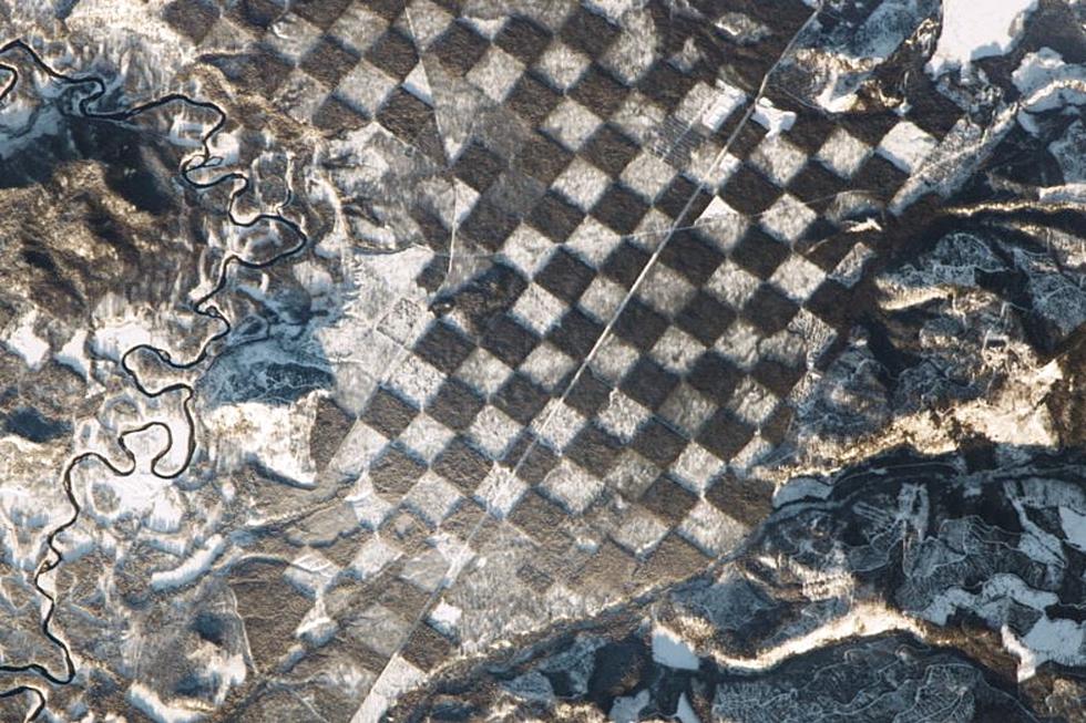
NASA Shared This Photo Of Idaho; Any Guess What This Is?
Being the space junkie that I am, photos taken from satellites thousands of miles above the Earth always fascinate me. It's even cooler when atmospheric images of places that are close to home go viral.
Some of you may have seen this image when it was first released by the space agency on January 4, 2017. The picture of this unique "checkerboarding" pattern along the Priest River in northern Idaho was taken by cameras aboard the International Space Station just before sunset.
The land shown in this photograph is currently used largely for tree harvesting, according to details shared at earthobservatory.nasa.gov. The city of Priest River is located 600 miles northwest of Twin Falls, in Bonner County, bordering the state of Washington. The checker board pattern was created due to the timber harvesting, with the white portions being snowfall covering younger planted trees.
The space station was hovering at roughly 214 nautical miles, at 5:28 p.m. (MT). The photo was taken with a Nikon D4 Electronic Still Camera, according to further data provided by NASA.
Space.com featured the photo in a December 30, 2017 gallery titled, "NASA's Best Earth-From Space Photos Taken By Astronauts in 2017." This region of Idaho is also used by the forest department as a lookout point during fire season.
What an amazing sight to have been taken in by crew members aboard the space station on that January day. I'm sure whatever direction cameras are pointed at that elevation produce spectacular images, but as far as pictures of Idaho landscape, that one is pretty magnificent.
More From News Radio 1310 KLIX


![NASA Can See Your Christmas Lights From Space [VIDEO]](http://townsquare.media/site/33/files/2019/12/GettyImages-1069073022.jpg?w=980&q=75)
![NASA Unveils New Spacesuits For the Moon & Mars [VIDEO]](http://townsquare.media/site/33/files/2019/10/GettyImages-464966054.jpg?w=980&q=75)

